

When the Hickory Underground Water Conservation District No. 1 was created in 1982, its primary purpose was the oversight and protection of the Hickory Aquifer. Since that time, all the other aquifers within the District’s boundary have been added to our jurisdiction. Still, the most productive aquifer under our authority is the Hickory. Because this aquifer is one of the most geologically complex in the State of Texas, this article will cover only the generalities.
The Hickory Aquifer is a minor aquifer extending across 19 counties in Central Texas. Our District only covers a small portion of this area: all of Mason County, most of McCulloch and San Saba Counties, and small portions of Concho, Menard, and Kimble Counties.
This Cambrian-aged (485.4 million to 541 million years ago) sandstone aquifer sits atop the Precambrian granite, creating a very distinctive landscape feature. In our region of Central Texas, the granite protrudes, surrounded by the outcrop. An outcrop is the area in which the formation is exposed at the land surface and corresponds to the recharge zone where the water enters the aquifer. Most of the recharge to the Hickory aquifer is from direct infiltration of precipitation in the outcrop. You’ve probably noticed the outcrop when you’ve driven through Mason County or southeastern McCulloch County. You can see the rusty red sandy soil and rock from the highway.
The sandstone is divided into three units. The lower unit containing rounded grains which has been historically used in the hydraulic fracturing of oil/gas wells. The middle Hickory is silty, and the upper is the rusty red sandstone. In the southwest corner of McCulloch County, all three layers combined can be as much of 480 feet thick. This is not a consistent thickness however and often in outcrop areas near the granite, this zone can be very thin with limited productivity.
As you move away from the outcrop along the downdip, the aquifer gets deeper and deeper. Some of the wells in the outcrop are less than 100’ deep while wells in the deeper downdip can be over 3000’ deep. To complicate matters, because of the tectonics that occurred during the geological formation, there is quite a bit of faulting, so the depths don’t follow a consistent pattern.
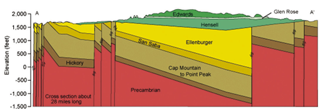
This cross section created by Paul Tybor in 1993 depicts the deepening and faulting as well as illustrates the distribution of other aquifers atop the Hickory. In the outcrop area, you would drill directly into the Hickory, while in other regions, you would have to pass through Edwards, Hensell, Ellenburger, San Saba, Cap Mountain, Welge and Point Peak. We hope to address these formations in future articles.
Understanding how these formations “stack” is fundamental to utilizing one of the tools on our interactive map found on our website. Go to <hickoryuwcd.org> and scroll down to the link for the All-in-One Map-App. Toggle on the layer “Surface Geology” and click on the colored layer to see which of these formations is found at the most superficial level. Knowing what is at the surface helps you understand which water-bearing formations can be found under the ground. If you have any questions while utilizing this application or about anything District related, do not hesitate to call us at 325-597-2785 or email <hickoryuwcd@yahoo. com>.
If the geology in this article intrigues you, visit the USGS site <https://txpub.usgs.gov/ txgeology/> for more details.
Hickory UWCD: PO Box 1214 * 111 E. Main / Brady, Texas 76825; 325-597-2785 phone / <http://www.hickoryuwcd. org>